Little Dry River Stream Restoration
Restoring Aquatic Organism Passage

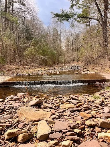
This image captures the downstream plunge effect caused by the concrete ford. The pool on the downstream side is not natural and is becoming deeper due to the water being accelerated across the concrete and plunging down on the downstream side.
Intro
The Little Dry River Stream site, located in George Washington National Forest near Fulks Run, VA, is an important waterway for aquatic organism passage through the Shenandoah Valley region into the Chesapeake Bay. The site currently has a large concrete culvert that is inaccessible for aquatic organisms, specifically rainbow trout, which migrate through this region. The culvert has a steep ledge, which the trout can not jump over. This also creates a stretch of the river with essentially no depth after the ledge which the trout can not swim through. A replacement is needed to allow trout passage and continue the natural shape of the channel. The temporary bridge also needs to be replaced with a permanent structure that will fit in with the channel design.

Seen here is the aquatic organism passage (AOP) obstruction on the right which is a concrete ford. On the left is a temporary bridge allowing electric utility vehicles to cross to a job site.
Current Efforts
Project Scope and Purpose
Our team is working to design a permanent bridge to replace the current rental structure, as well as a new culvert that improves aquatic organism passage (AOP), supports natural channel function, and enhances the aesthetic of the surrounding environment. All design work will follow the U.S. Department of Agriculture’s AOP guidelines to ensure ecological compatibility.
Permitting and Regulatory Compliance
To support long-term implementation, we are actively reviewing existing permits, preparing new permit applications, and ensuring that all design elements align with local, state, and federal environmental regulations. This includes obtaining the necessary approvals for both the bridge replacement and stream modifications.
Stream Design Process
We are conducting detailed site and reference reach surveys to inform our stream restoration design. These measurements are used to create accurate cross sections, calculate stream velocity and discharge, and ultimately develop a detailed 3D model of the site to guide engineering and ecological planning.

The 2026 James Madison University Senior Stream Restoration Capstone Team. (I’m second from right)